
Texas Science Teacher Resource Hub
Free scope and sequences, TEKS breakdowns, phenomenon ideas, and engagement activities for the 2024 Texas science standards.

🚀 Jump to Your Grade
Pick your grade level and go straight to your TEKS standards, aligned resources, and teaching tools.
-
4th
→4th Grade Science20 standards • Matter, Earth, Energy & more
-
5th
→5th Grade Science19 standards • Matter, Ecosystems, Space & more
-
6th
→6th Grade Science24 standards • Forces, Energy, Matter & more
-
7th
→7th Grade Science27 standards • Cells, Chemistry, Earth & more
-
8th
→8th Grade Science24 standards • Newton's Laws, Space, Genetics & more
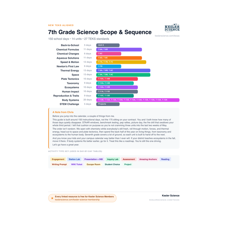
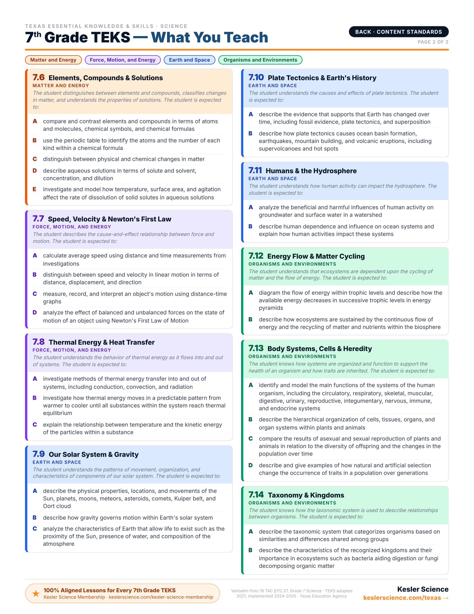
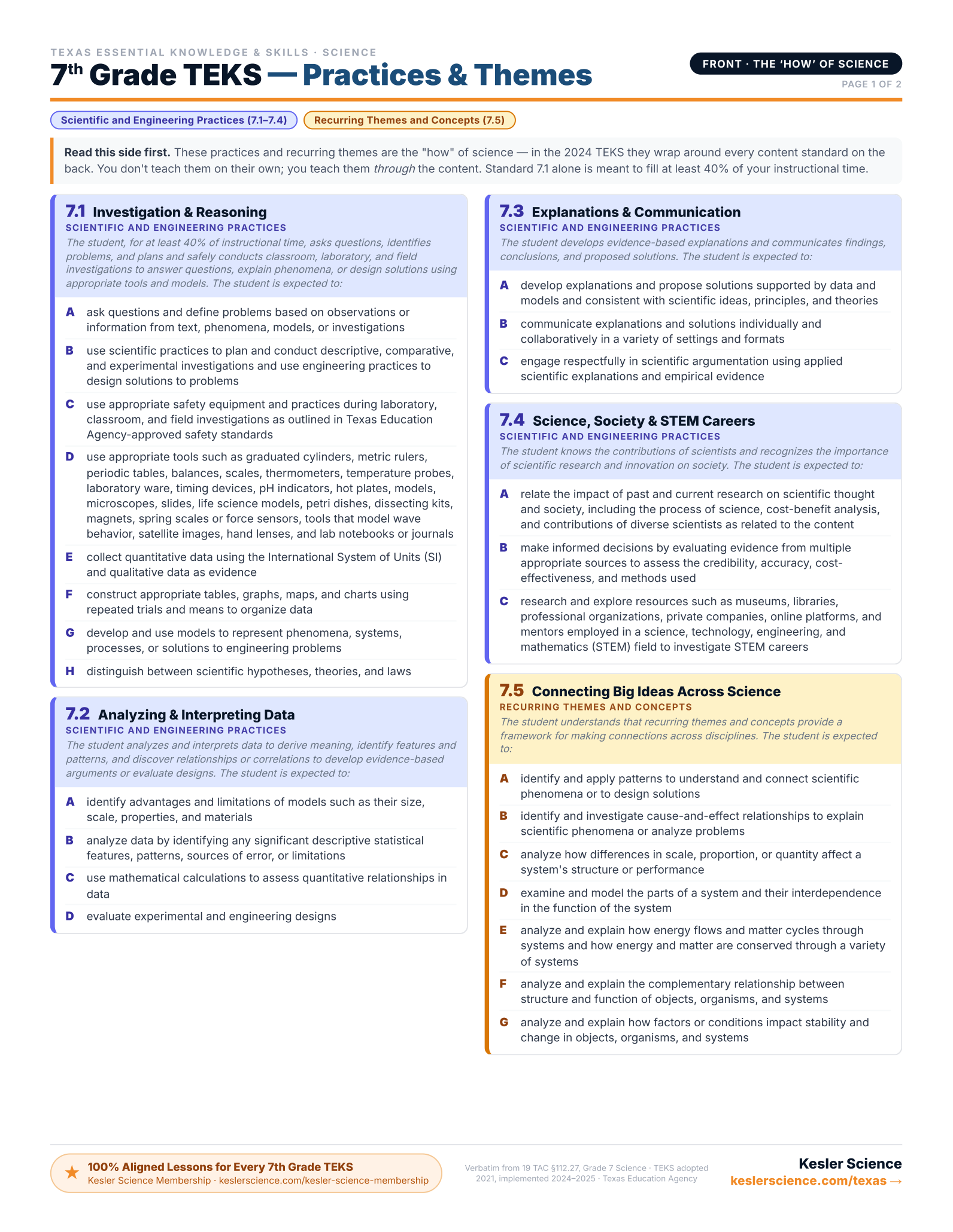
7th Grade TEKS Standards
Click any standard to see what it means, how to teach it, where students get stuck, and aligned resources.
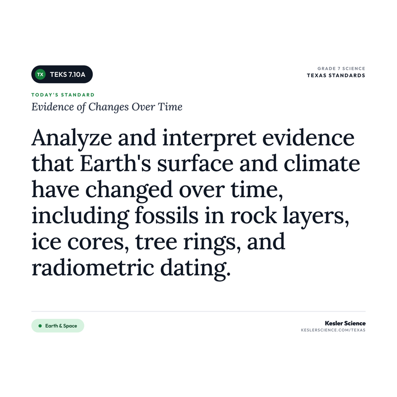
Evidence of Changes Over Time
"Describe the evidence that supports that Earth has changed over time, including fossil evidence, plate tectonics, and superposition."
💡 What This Standard Actually Means
"Describe". Students are describing the evidence that supports that Earth has changed over time. The standard names three specific kinds of evidence to focus on: fossil evidence, plate tectonics, and superposition. This is a big shift from the old version, which focused on ice cores, tree rings, and radiometric dating. The new TEKS leans on geological and biological evidence preserved in the rock record. Instruction can take many forms, such as fossil-layer investigations, sedimentary rock layer analysis, plate boundary mapping, and superposition stacking activities with paper or playdough.
Earth is roughly 4.6 billion years old. That number is hard to wrap your head around, but the standard is about how scientists know the planet has changed during all that time. The 2024 TEKS lists three specific lines of evidence kids need to be able to describe.
Fossil evidence shows what kinds of organisms lived in different places at different times. When scientists find tropical plant fossils in Antarctica or marine fossils on top of a mountain, that's evidence the climate, location, or elevation has changed dramatically. Fossils of similar animals show up on continents that are now thousands of miles apart, suggesting those continents used to be connected. The fossil record tells the story of life evolving over hundreds of millions of years and the planet shifting around it.
Plate tectonics is the evidence that Earth's outer shell is broken into large pieces (plates) that slowly move. Coastlines on different continents fit together like puzzle pieces, especially the bulge of South America and the curve of Africa. Identical rock formations and fossils appear on continents that are now separated by oceans. Earthquake and volcano patterns line up along plate boundaries. All of that points to continents that have moved, oceans that have opened and closed, and mountain ranges that have risen as plates collided.
Superposition is the idea that in undisturbed sedimentary rock layers, older layers sit on the bottom and younger layers stack on top. By reading down through the layers, scientists can build a timeline of when different events happened, when certain organisms lived, when sea levels changed, and when major events like volcanic eruptions or asteroid impacts happened. Together, these three kinds of evidence give students a clear picture: Earth's surface has been changing the whole time, and the rocks themselves hold the record.
The move that worked for me on this one was putting each type of evidence on its own station and having kids rotate through like detectives. At one station I'd have a picture of a rock face with fossil layers drawn in. At another, a labeled diagram showing superposition (oldest layers at the bottom) so they could practice reading the rock record. At a third, a plate-tectonics map with arrows showing how continents have moved. They'd record "what this tells us" at each spot. By the end, they weren't memorizing a list. They were treating Earth like a case file. That framing stuck way longer than any timeline I ever made them copy down.
⚠️ Misconceptions Your Students May Have
These are some of the most common misconceptions. Knowing what to look for can help you get ahead of them.
"Fossils can form in any kind of rock"
Fossils are found primarily in sedimentary rock. Sedimentary rock forms in slow, gentle layers, which is the exact environment that preserves plant and animal remains. Igneous rock forms from extreme heat, and metamorphic rock forms under intense heat and pressure. Both conditions destroy the delicate structures that become fossils. When students look at a fossil diagram, they should expect those layers to be sedimentary.
"Continents have always been right where they are now"
The continents have moved a lot, and they're still moving. Around 200 million years ago, the continents we know today were squashed together into one giant landmass called Pangaea. Plate tectonics slowly broke them apart and sent them drifting to where they are now. Matching coastlines (look at South America and Africa), matching fossils across oceans, and matching rock layers on different continents are all evidence that the continents used to be joined. Earth's surface is not fixed.
"You can tell the age of a rock layer just by looking at how thick it is"
Thickness doesn't equal age. The law of superposition says that in undisturbed sedimentary layers, the bottom layer is older than the layer above it, no matter how thick or thin those layers are. A thin layer near the bottom could represent thousands of years of slow deposition. A thick layer above could have been laid down in a single flood. Order tells you the sequence of events. Thickness only tells you how much sediment got deposited.
"If layers are tilted or broken, scientists can't figure out the order"
Rock layers get folded, tilted, and faulted by tectonic activity all the time. Geologists have tools for this. They look at features like cross-cutting relationships (a fault is younger than the rocks it cuts through) and the original horizontal orientation of sediment. The sequence still reads if you know what to look for. Students shouldn't assume broken layers mean broken information.
📓 Teaching Resources for 7.10A
These resources are aligned to this standard.


100% Aligned Lessons for Every TEKS You Teach
Kesler Science Plus puts thousands of ready-to-teach lessons and activities in your hands, so you can boost engagement and get your planning time back. Trusted by schools and districts all over the great state of Texas.
🌎 Phenomenon Ideas for 7.10A
Use these real-world phenomena to anchor your lesson. Show students the phenomenon first, let them wonder, then build toward Evidence of Changes Over Time as the explanation.
Whale Fossils in the Middle of the Desert
In Egypt's Wadi Al-Hitan, hundreds of whale fossils sit in the open desert, hundreds of miles from the nearest ocean. These are full skeletons, some more than 40 feet long, preserved in sedimentary rock. The area is now one of the driest places on Earth. Whales do not live in deserts. So how did they get there?
"If whales can only live in the ocean, and these whale fossils are buried in desert rock layers, what must have been different about this place millions of years ago?"
The Same Fossil on Two Continents
Mesosaurus was a small reptile that lived in shallow inland seas and saline lagoons around 280 million years ago. Its fossils have been found in only two places on Earth: a strip of South America and a strip of southern Africa. Mesosaurus could not have swum across the Atlantic Ocean. So how did the same animal end up fossilized on two continents that are now thousands of miles apart? When you slide South America east and Africa west on a map, the two fossil zones line up perfectly.
"How can the same freshwater reptile end up as fossils on two continents separated by an ocean? What does this tell us about how Earth's surface has changed since this animal was alive?"
Reading the Grand Canyon Like a Calendar
Stand at the rim of the Grand Canyon and you can see almost a mile of layered rock stacked below you. The deepest layers were laid down first, hundreds of millions of years ago. The layers above came later, one on top of the other, all the way up to the top of the canyon. Each layer holds the fossils of the plants and animals living on Earth at that time. Geologists read those layers from bottom to top like flipping through the pages of Earth's history book.
"In an undisturbed canyon, why do we know the bottom layer is older than the layer above it? What does the law of superposition let us say about the order of events in Earth's history?"
💡 Free Engagement Ideas for 7.10A
Edible Rock Layers
Build sedimentary layers in clear plastic cups using different colored snack foods (crushed graham crackers, vanilla pudding, chocolate chips, gummy worms for fossils). Students layer from bottom to top, then trade cups with another group. The receiving group "excavates" and reads the layers using the law of superposition.
Pangaea Puzzle Cut-Out
Print a world map showing all seven continents. Have students cut out each continent and try to fit them back together into one supercontinent. Most kids will get South America and Africa to lock together right away because of the matching coastlines. India will surprise them when they realize it slides up under Asia. Once their puzzle is together, give them a sheet showing where Mesosaurus fossils, ancient mountain belts, and matching rock layers have been found. They'll see the evidence pile up that the continents used to be joined.
Stack the Story Layers
Give each group five strips of construction paper in different colors and a list of "Earth history" events to assign in order: a swamp formed, a sea moved in, a meteor hit, lava covered the area, the seas drained. Each group decides on the order and stacks their strips with the oldest event on the bottom and the youngest on top. Add a fossil to each layer (a little drawing of a fern, a fish, a dinosaur, a mammal). Trade strips with another group and try to read their Earth history just by reading the layers from bottom to top, exactly the way a geologist would. Practices the law of superposition with a story they made themselves.
Three Stations of Evidence
Set up three numbered stations around the room, each with a different type of evidence. Station 1: Fossil evidence. Lay out picture cards of Mesosaurus, Glossopteris, and a Cynognathus fossil distribution map. Station 2: Plate tectonics. Lay out a Pangaea reconstruction and a current world map. Station 3: Superposition. Lay out a printed Grand Canyon cross-section with named layers. At each station, students write one sentence on a sticky note explaining what the evidence shows about how Earth has changed. Rotate every five minutes. End by sharing out which evidence was the most convincing and why.
🎯 What Approaches, Meets, and Masters Thinking Look Like
Here is what student thinking at each level looks like on this one task, so you know what to look for and how to move a student up.
A diagram shows a cliff of undisturbed sedimentary rock with four layers, labeled from top to bottom: Layer 1 (top), Layer 2, Layer 3, and Layer 4 (bottom). Layer 2 is thick, and the layers below it are thin. A trilobite fossil is found in Layer 4, and a shark tooth fossil is found in Layer 2. Use the law of superposition to put the four layers in order from oldest to youngest, and explain how you know which fossil is older.
- The layers ordered from oldest to youngest using position: Layer 4 (bottom) is oldest, Layer 1 (top) is youngest.
- A clear statement of the law of superposition in their own words: in undisturbed layers, the bottom layer formed first.
- The trilobite (Layer 4) identified as the older fossil because it sits in the bottom layer.
- The reasoning tied to the order the layers were laid down, not to anything they happened to notice first.
- The student treats these as sedimentary layers that stacked over time, one on top of the last.
- An explanation that connects fossil age to layer position, not to layer thickness.
- The thick Layer 2 handled correctly: being thick does not make it older than the thin layers below it. That is the easiest place to slip.
The bottom layer is the oldest and the top is the youngest. But I think the shark tooth is older than the trilobite. Layer 2 is way thicker than the other layers, so it took a longer time to build up. A thicker layer means more years went by, so the fossil in the thick layer must be the oldest one.
From oldest to youngest the order is Layer 4, then Layer 3, then Layer 2, then Layer 1. The law of superposition says that in undisturbed rock the bottom layer formed first and each new layer stacks on top. So the trilobite in Layer 4 is older than the shark tooth in Layer 2, because Layer 4 was already there before Layer 2 was laid down. The thickness of Layer 2 does not matter for age. It just means more sediment piled up there.
Oldest to youngest: Layer 4, Layer 3, Layer 2, Layer 1. Sediment settles a little at a time, so the layer on the bottom had to be there first and every layer above it landed later. That is the law of superposition. The trilobite in Layer 4 is older than the shark tooth in Layer 2 because its layer was already in place before Layer 2 formed. The thickness of Layer 2 tells me how much sediment built up, not how long ago, so it does not change the order.
This same idea works outside of rock. If I never clean out my locker, the papers pile up in order, so the worksheet at the very bottom is the oldest one and the one on top is from today. It does not matter that some days I shove in a thick stack and other days just one sheet. The bottom is still the oldest, because of the order things landed, not how thick the pile is.
Every 7th-Grade Science TEKS on One Page
The color-coded, front-and-back cheat sheet I wish I'd had — every standard, organized by reporting category. Print it and reference it all year long. This will be your new favorite document!
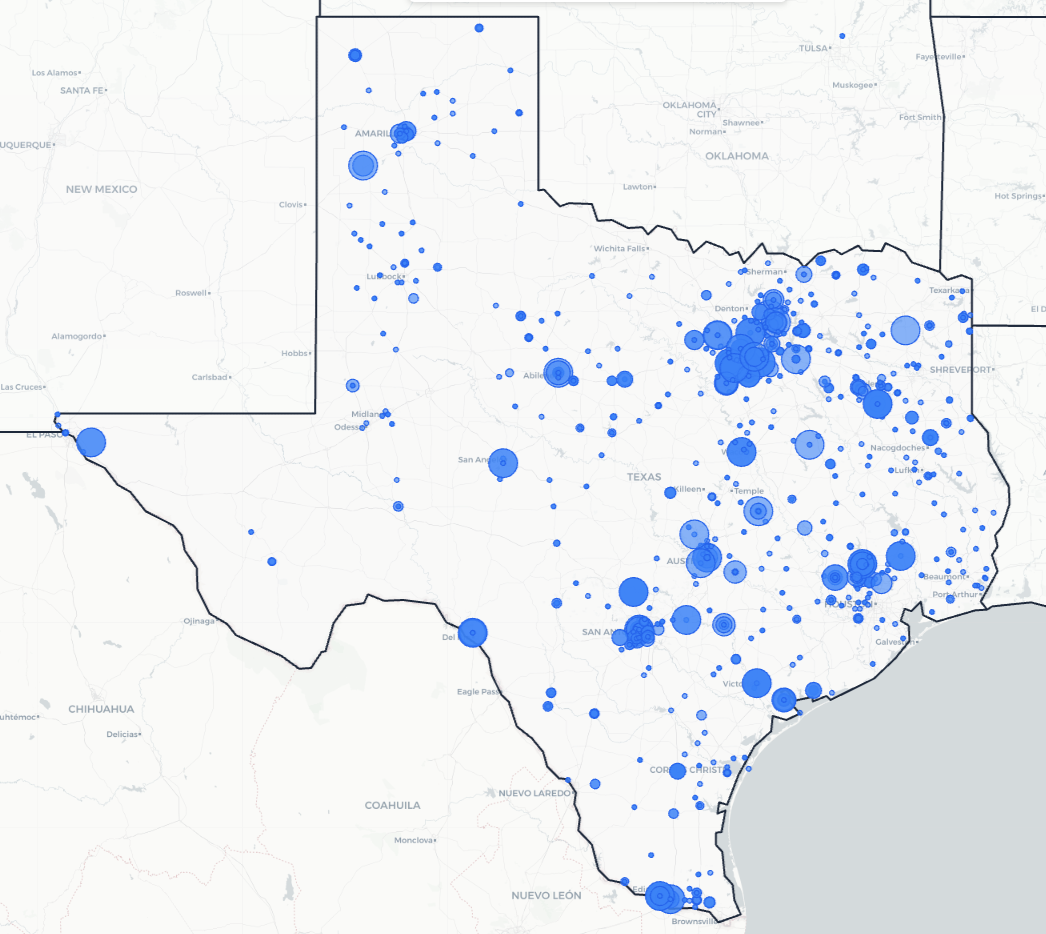
Trusted Across Texas
From the Rio Grande Valley to the Panhandle, Texas science teachers are using Kesler Science to save time and engage students.
Texas Schools and Districts
Love Kesler Science
What Teachers Are Saying
Give Your Science Teachers Everything They Need
School and district licenses give your teachers access to every resource they need, including station labs, inquiry labs, anchoring phenomena, presentations, escape rooms, and much more. One purchase covers the grade levels you need.
- PO-friendly. We accept purchase orders
- Volume discounts for 11+ teachers
- Complimentary Kesler Science Plus orientation for 4+ teachers
- Three free implementation PD sessions for departments of 11+
- Aligned to the 2024 TEKS standards
See It in Action
Book a walkthrough and we'll show you how Kesler Science fits your campus.
Book Demo CallNo pressure, no hard sell