
Middle School Inquiry Lab on Natural Hazards
In this lab students will analyze data on patterns of natural hazards across the U.S. using a web-based interactive mapping program and read articles about their detection. Students will then build a seismograph to simulate the technologies used to predict natural disasters.
Each inquiry lab will contain an essential question that will drive the lesson and make students think. For this lesson, the essential question is:
- How do scientists monitor and predict natural hazards?
BACKGROUND INFORMATION AND MATERIALS LIST:
Students will begin the lab by reading the essential question and background information. This can be done individually, as lab groups, or as a whole class. If you consider lab groups, you also might include some type of whole class formative checks before digging into the lab.


Materials List:
- internet or printed maps with geophysical hazards
- seismograph materials:
- cardboard box (without flaps)
- plastic cup
- felt tip marker
- string
- small rocks, sand, or marbles
- clay
- paper
- scissors
PROCEDURE:
This inquiry lab contains two parts students will need to complete. In the first part students will use the internet to work with interactive maps or study previously printed maps with specific geophysical hazards. Using either medium, students will try to identify patterns as to where hazards such as earthquakes and volcanoes are occurring the most.
In the second section of the lab, students will create a working seismograph to detect ground movement. Following instructions, students will simulate what seismographs record during an earthquake. Students will also try pounding on the table or creating some other type of vibrations in order for the seismograph to detect their movements.
CHECK FOR UNDERSTANDING:
At this point in the lab, students will be checked for understanding by answering questions about their findings. Here are a few that come with the lab:
- In the U.S., where are the majority of earthquakes located?
- Are earthquakes scattered randomly or do they follow a pattern?
- Where are volcanoes most likely to be located around the world?
- Explain what types of natural disasters are represented by the data set:
- drought –
- geophysical –
- hydrological –
- How can a seismograph help detect volcanic activity?
CONCLUSION
Students will go back to the essential question and write a CER (Claim, Evidence, Reasoning) to conclude the lab. Once completed, students will reflect back on their learning by answering the following questions:
- Even with all the different technologies available to scientists today, why is it still difficult to predict where and when these geophysical natural hazards will occur?
- If you were an architect that built skyscrapers, where would be the safest place to build it? Explain why you chose that location.
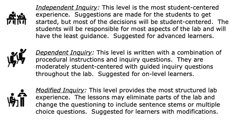
MODIFIED AND INDEPENDENT INQUIRY VERSIONS
All of the Kesler Science inquiry labs come with three different modification levels. Each lab is differentiated using the icons below.
STANDARDS ALIGNMENT
NGSS: MS-ESS3-2 – Analyze and interpret data on natural hazards to forecast catastrophic events and inform the development of technologies to mitigate their effects.


