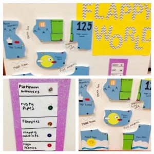
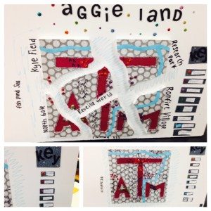
This week we have been talking about plate tectonics and Pangaea. One of the projects that I assigned the students is called the Pangaea project. They are to create a new world that shows Alfred Wegener’s 3 key pieces of evidence that he used to come up with for the Continental Drift Theory. The need to show that the continents fit together like puzzle pieces, that there was fossil evidence found on separate continents, and that landforms matched up on each continents. Below you will see some sample projects and the guideline and rubric that I used.
Download the Full Pangaea Project Guidelines and Rubric
These are the guidelines that I used for the project. The rubric is included in the download link above.
Each student will create a world with crustal plate movement using Alfred Wegener’s Continental Drift Theory data. The following criteria will be utilized to complete the project:
– Each world should have at least 6 continents on the planet that you create. The world should be themed to whatever you would like.
– Three copies of the continents should be made. Two copies of the continents should be cut out. One of the cut-outs should be placed on a planet (on poster board) as they appear today. The second set of cutout continents should be placed in a plastic sandwich bag (attached to the back of the poster) and will be used by classmates to solve your Pangaea project. The third set of continents should be put together (on the poster board) the way the continents appeared as a super-continent millions of years ago.
– One major landform should be included on the super-continent that spans across at least 2 of the minor continents. Landforms could include mountain ranges, rivers, etc.
– There should be a least 4 types of fossils placed on the continents that show that certain land masses match up. Create names for the fossils and make a key for the fossil symbols and their names.
– Name at least 4 bodies of water (oceans, seas, lakes) that are between your continents on the present day set of continent cut-out.
– Be accurate and neat! Be Creative!
Opportunities for extra credit
– More than one major landform
– More than 4 fossils
– Complete the project before the due date
I’m thinking about making this project digital next year. What do you think? Can you think of any Web tools that would work really well with it?
Download Over $100 in FREE Resources
For Middle School Science
Simply create a login below and gain immediate access to a selection of our Kesler Science product line worth $100 - for FREE. There's a full version of every product type! You'll also join tens of thousands of middle school science teachers who receive timely tips and strategies straight to their inbox.

